The allure of Big Sur, with its breathtaking coastline, towering redwoods, and dramatic vistas, beckons to travelers from around the world. However, the rugged beauty of this region is often juxtaposed with the harsh realities of nature, including landslides, wildfires, and infrastructure challenges that can lead to road closures. For those planning to embark on the scenic journey along Highway 1, being informed about potential road closures and knowing the best alternatives can make all the difference between a smooth, enjoyable trip and a frustrating ordeal.
Understanding Big Sur Road Closures
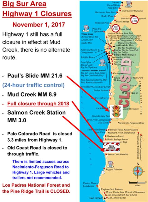
Big Sur, spanning over 90 miles of California’s Central Coast, is prone to road closures due to its geologically unstable terrain. The region’s steep cliffs, heavy rainfall, and wildfire-scarred landscapes can trigger landslides, mudslides, and other events that necessitate the temporary or sometimes prolonged closure of Highway 1. These closures can significantly impact travel plans, especially for those not prepared with alternative routes or accommodations.
Pre-Trip Planning: The Key to Success
Before embarking on your Big Sur adventure, it’s crucial to check for any current or anticipated road closures. The California Department of Transportation (Caltrans) and local tourism boards provide up-to-date information on road conditions through their websites and social media channels. Understanding the current status of the roads can help you plan your itinerary more effectively, including booking accommodations and arranging for activities that fit within the constraints of any closures.
Navigating Alternatives: Flexible Travel Planning
Flexibility is key when traveling through Big Sur. If a portion of Highway 1 is closed, several alternative routes and strategies can help you navigate the region:
US-101 and Highway 156: For those traveling from the north, considering an inland route via US-101 to Highway 156 can provide a detour around closed sections of Highway 1. This route, although longer, offers its own set of attractions, including the Salinas Valley and the quaint town of Monterey.
Nacimiento-Fergusson Road: This scenic, though sometimes bumpy, road connects Highway 1 to US-101 via the Los Padres National Forest. It’s an excellent option for those who wish to avoid major detours, offering breathtaking views of the forest and surrounding peaks.
17-Mile Drive and Pebble Beach: If your main interest lies in the southern parts of Big Sur and you’re faced with a closure near Monterey, consider exploring the famous 17-Mile Drive. This scenic route, with its world-renowned golf courses and stunning coastal views, can be a satisfying alternative, offering a glimpse into the region’s unique ecosystem and luxury.
Practical Tips for Navigating Big Sur
- Stay Informed: Regularly check Caltrans and local news for updates on road conditions.
- Be Flexible: Be prepared to adjust your itinerary based on current or emerging road closures.
- Pack Accordingly: Bring essentials like food, water, and a first-aid kit, as services may be limited in areas affected by closures.
- Explore Alternatives: Consider the alternative routes mentioned and plan for additional time and potential accommodations.
Future Trends in Big Sur Accessibility
As climate change and natural events continue to impact the stability of Big Sur’s landscapes, there’s a growing focus on sustainable tourism and resilient infrastructure. Efforts to improve early warning systems for landslides and to reinforce the highway are underway, along with initiatives to protect the area’s biodiversity and support local communities affected by tourism fluctuations. Travelers can contribute by choosing eco-friendly accommodations, supporting local businesses, and respecting any restrictions or guidelines aimed at preserving this unique environment.
Conclusion
Big Sur, with its dramatic landscapes and challenging geography, presents a unique set of travel considerations. By staying informed, being prepared to adapt, and considering the broader impact of your travel choices, you can navigate the potential complexities of road closures and enjoy the unparalleled beauty that Big Sur has to offer. Whether you find yourself winding along the iconic Highway 1, exploring detour routes, or simply absorbing the serene beauty of the region, the essence of Big Sur—a place where nature’s power and beauty converge—remains an unforgettable experience.
What is the best way to check for Big Sur road closures before my trip?
+The California Department of Transportation (Caltrans) and local tourism boards provide the most accurate and up-to-date information on road conditions through their official websites and social media channels. It’s also a good idea to check for any travel advisories issued by local authorities.
Are there any alternative routes if Highway 1 is closed in Big Sur?
+Yes, several alternatives exist, including taking US-101 and Highway 156 for a detour around closed sections, or using Nacimiento-Fergusson Road for a more scenic, though sometimes rugged, route through the Los Padres National Forest.
How can I support sustainable tourism in Big Sur?
+Supporting local, eco-friendly businesses, respecting environmental restrictions, and choosing accommodations that adhere to sustainable practices are excellent ways to contribute to the preservation of Big Sur’s unique environment and communities.