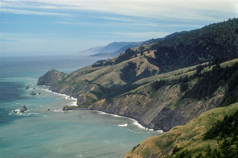
Tucked away in the northwest corner of California, the Lost Coast is a rugged and remote stretch of coastline that defies the typical image of the Golden State’s sun-kissed beaches and bustling boardwalks. This 80-mile stretch of wilderness, which spans from the mouth of the Mattole River in Humboldt County to the town of Rockport in Mendocino County, is a haven for outdoor enthusiasts, nature lovers, and those seeking a glimpse of California’s untamed beauty.
The Lost Coast earned its name due to its inaccessibility and isolation. The rugged terrain, dense forests, and lack of major highways have kept this region relatively undeveloped, preserving its natural beauty and making it a challenging yet rewarding destination for adventurers. The coastline is dotted with secluded beaches, hidden coves, and towering sea stacks, carved out by the relentless pounding of the Pacific Ocean.
One of the most distinctive features of the Lost Coast is its unique geology. The region is part of the Mendocino Triple Junction, where three tectonic plates converge, creating a complex landscape of faults, folds, and uplifts. This geological activity has shaped the coastline into a dramatic series of cliffs, headlands, and valleys, with rocks dating back to the Jurassic era. The iconic rock formations, such as the iconic Punta Gorda Lighthouse and the towering sea stacks at Shelter Cove, are a testament to the region’s turbulent geological history.
For hikers and backpackers, the Lost Coast Trail is a bucket-list destination. This 25-mile trail stretches from Mattole River to Black Sands Beach, winding its way through dense forests, across scenic ridge lines, and along the coastline, offering breathtaking views of the Pacific Ocean. The trail is considered one of the most challenging in the state, with steep inclines, uneven terrain, and unpredictable weather conditions. However, the rewards are well worth the effort, with stunning vistas, secluded campsites, and an unparalleled sense of wilderness solitude.
In addition to its natural beauty, the Lost Coast is also steeped in history and culture. The region has been home to the Native American tribes of the Wiyot, Yurok, and Mattole for thousands of years, with evidence of their presence still visible in the form of ancient petroglyphs, burial grounds, and traditional fishing sites. The arrival of European settlers in the 19th century brought significant changes to the region, with the establishment of logging camps, ranches, and small towns. Today, the Lost Coast is a testament to the complex and often contentious relationship between human activity and the natural environment.
Despite its remoteness, the Lost Coast is not without its challenges. The region is vulnerable to the impacts of climate change, including sea-level rise, increased storm frequency, and changes in ocean temperature and chemistry. Additionally, the pressures of tourism and development pose a threat to the region’s fragile ecosystem and cultural heritage. Efforts are underway to protect and preserve the Lost Coast, including the establishment of the King Range National Conservation Area and the Sinkyone Wilderness State Park, which provide a framework for sustainable land use and conservation.
For those planning to visit the Lost Coast, it’s essential to be prepared for the challenges and uncertainties of this wilderness region. Weather conditions can be unpredictable, with dense fog, strong winds, and heavy rainfall common throughout the year. The terrain is rugged and unforgiving, with steep cliffs, fast-moving rivers, and uneven trails. However, with proper planning, equipment, and experience, the Lost Coast offers an unparalleled opportunity for adventure, exploration, and connection with nature.
| Location | Distance from Nearest Town | Notable Features |
|---|---|---|
| Mattole River | 20 miles from Ferndale | Mattole River Estuary, historic town of Petrolia |
| Shelter Cove | 25 miles from Garberville | Shelter Cove Beach, Cape Mendocino Lighthouse |
| Rockport | 15 miles from Fort Bragg | Rockport Beach, Mendocino Headlands State Park |

In conclusion, the Lost Coast of California is a unique and captivating region that offers a glimpse into the state’s untamed wilderness and rich cultural heritage. From its dramatic coastline and rugged terrain to its complex geological history and vibrant cultural landscape, the Lost Coast is a destination that inspires awe, wonder, and a deep appreciation for the natural world.
What is the best time to visit the Lost Coast?
+The best time to visit the Lost Coast is from May to October, when the weather is generally mild and dry. However, the region can be visited year-round, with each season offering unique advantages and challenges. Winter storms can make the roads and trails impassable, while summer fog can limit visibility. Spring and fall are ideal for hiking and backpacking, with mild temperatures and fewer crowds.
What are the most popular activities on the Lost Coast?
+The most popular activities on the Lost Coast include hiking, backpacking, camping, fishing, and surfing. The region is also known for its scenic driving routes, with the Lost Coast Highway (Hwy 1) offering breathtaking views of the coastline. Wildlife watching, including whale watching and birding, is also a popular activity, with the region home to a diverse range of species.
How do I plan a trip to the Lost Coast?
+Planning a trip to the Lost Coast requires careful preparation and research. Start by checking the weather forecast and road conditions, and plan your itinerary accordingly. Book your accommodations and campsites in advance, especially during peak season. Bring plenty of food, water, and supplies, as services can be limited in the region. Finally, be prepared for the challenges of wilderness travel, including rugged terrain, unpredictable weather, and limited cell phone reception.